
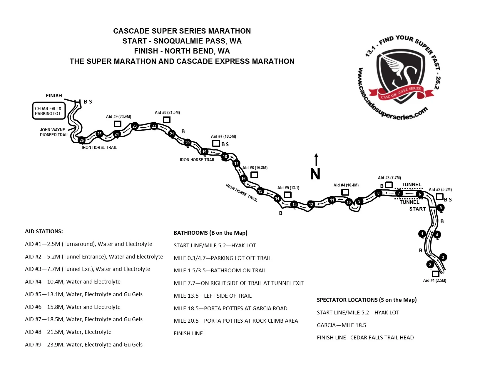
COURSE INFORMATION AND MAPS

MARATHON COURSE:
The course is one of the fastest in the country. The low starting elevation of 2,550' and gentle decent makes the courses great for fast times. It is the perfect race to set a PR, snag a BQ and have a great time. Don't let "trail" in the description deter you. The courses are smooth and runnable much like road events. You can expect fast feet with 1,500' of total elevation loss at a consistent grade. Beginning at Snoqualmie Pass, the race makes a 5 mile out and back on the Iron Horse trail before entering a 2.4 mile tunnel originally bored through the mountain for trains. The first 7.5+ miles of the course are essentially flat with minimal elevation gain or loss. After emerging from the darkness, the course begins its downhill over the remaining 17.5 miles. You cross old railroad bridges and beautiful river gorges, run by waterfalls and lush Pacific Northwest Forests, all on your journey to a fast, friendly finish at Rattlesnake Lake. The course is USATF certified (Certification Number: WA17029RMB).
The course runs from Hyak Parking Lot at Snoqualmie Pass to Rattlesnake Lake State Park. The entire course utilizes the Iron Horse Trail.
The elevation profile of the course is very smooth on the downhill. The first 5.2 miles of the course are essentially flat, but have some minor up and downs.

Official USATF Course Certification Map:

Race Start - Hyak Access Point, Snoqualmie Pass, Washington
The race starts at the Hyak trailhead for the John Wayne Pioneer trail just east of Snoqualmie Pass. After a 5 mile out and back section runners will be handed a flashlight prior to entering the 2.4 mile long tunnel. You are welcome to keep the flashlight or drop it at the exit of the tunnel. If you prefer to have your own headlamp or flashlight you will be REQUIRED to keep it the entire race. Once you get about 50 yards into the tunnel, you can see a pinpoint of light ahead of you which is the end of the tunnel over 2 miles away.
Race Finish - Rattlesnake Lake Park, North Bend, Washington
The course is exhilirating for your eyes. Runners continue traversing through forested slopes to the Iron Horse State Park trailhead and epic finish at Rattlesnake Lake.
You can find an interactive course map at the below link at MapMyRun. Please note the elevation profile is incorrect. There is no large hill on the course! This is the section that runs under the mountain.
Click Here for Interactive Course Map
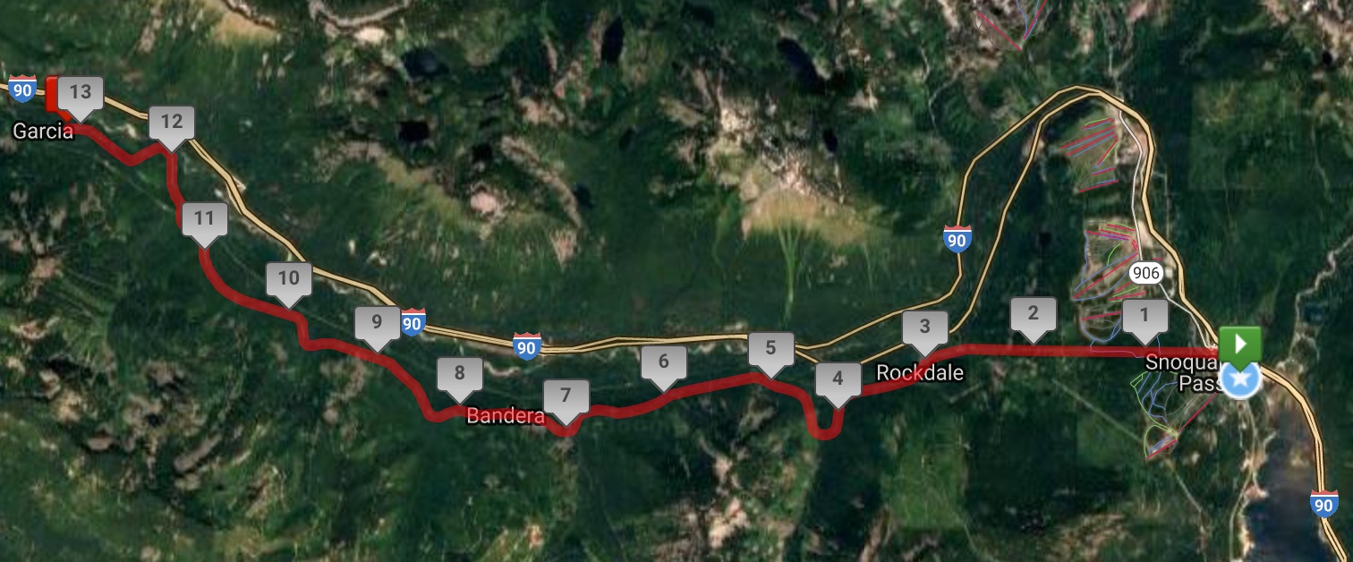
HALF MARATHON COURSE:
The half marathon course is entirely downhill. It utilizes the same start area as the marathon course however it does not have an out and back section. Runners will begin at Hyak and quickly enter the tunnel. Runners will be handed a flashlight prior to entering the 2.4 mile tunnel. You are welcome to keep the flashlight or drop it at the exit of the tunnel with a volunteer. If you prefer to have your own headlamp or flashlight you will be REQUIRED to keep it the entire race. After emerging from the tunnel, the downhill portion of the course begins. You will run down the gentle grade, cross railroad trestles, run over creeks and by small waterfalls on your journey to a fast finish at Garcia! The USATF Certification number is WA17002LB.
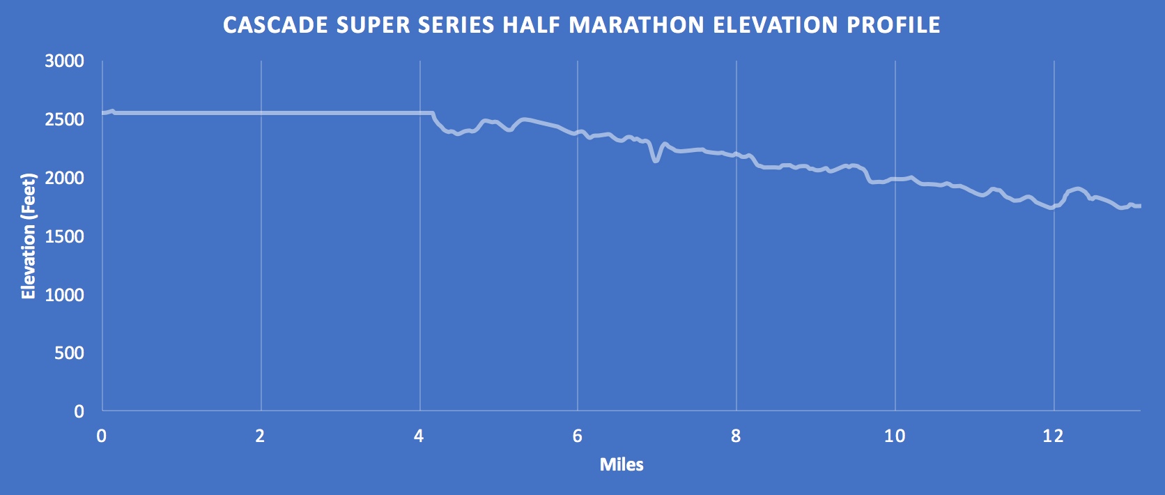
The half elevation profile is basically all downhill, except for the beginning which is flat as you run through the mountain. The course starts at 2,550' and ends at about 1,750' for 800' of total gentle descent.
Race Start - Hyak Access Point, Snoqualmie Pass, Washington
Race Finish - Garcia Access Point, North Bend, Washington
You can find an interactive course map on MapMyRun linked below. Please note that the elevation profile on map my run is not correct. There is no hill at the start!